Kahve Tabela atlas statistics
Cultural heritage statistics
How the Kahve Tabela atlas's 15,825 heritage records distribute across 81 provinces and 11 categories; 12,850 are grounded in Wikidata. Citable tables.
- heritage records in the atlas
- 15,825
- provinces covered
- 81/81
- grounded in Wikidata
- 12,850
Top 10 provinces in the atlas by heritage records
All 81 provinces
- İstanbul2,619
- Antalya797
- İzmir792
- Muğla633
- Ankara616
- Kırklareli604
- Çanakkale594
- Aydın480
- Edirne470
- Mersin451
- Konya392
- Tekirdağ297
- Kayseri248
- Manisa248
- Balıkesir242
- Bursa241
- Nevşehir228
- Denizli225
- Eskişehir222
- Hatay211
- Erzurum201
- Batman193
- Sivas186
- Kocaeli181
- Afyonkarahisar163
- Diyarbakır161
- Şanlıurfa160
- Gaziantep155
- Mardin148
- Malatya141
- Kastamonu139
- Adana137
- Trabzon132
- Samsun131
- Van130
- Artvin128
- Çorum127
- Kütahya124
- Kırşehir122
- Yozgat113
- Aksaray112
- Isparta103
- Karaman94
- Kahramanmaraş93
- Ordu92
- Tokat86
- Uşak84
- Giresun82
- Burdur81
- Çankırı80
- Bilecik78
- Rize75
- Gümüşhane73
- Niğde70
- Kars68
- Sinop57
- Amasya56
- Zonguldak56
- Şırnak55
- Erzincan51
- Adıyaman48
- Elazığ42
- Bayburt41
- Bitlis40
- Ağrı39
- Sakarya39
- Siirt39
- Hakkâri38
- Bolu37
- Muş37
- Bartın36
- Karabük33
- Yalova33
- Ardahan30
- Düzce28
- Kilis27
- Osmaniye27
- Iğdır26
- Tunceli25
- Kırıkkale17
- Bingöl15
By category
| Category | Records | Share |
|---|---|---|
| Monument | 5,526 | 34.9% |
| Ancient site | 4,206 | 26.6% |
| Natural site | 1,795 | 11.3% |
| Museum | 1,137 | 7.2% |
| Other | 927 | 5.9% |
| Castle | 808 | 5.1% |
| Ruins | 446 | 2.8% |
| Tomb | 398 | 2.5% |
| Mosque | 254 | 1.6% |
| Historic building | 213 | 1.3% |
| Church | 115 | 0.7% |
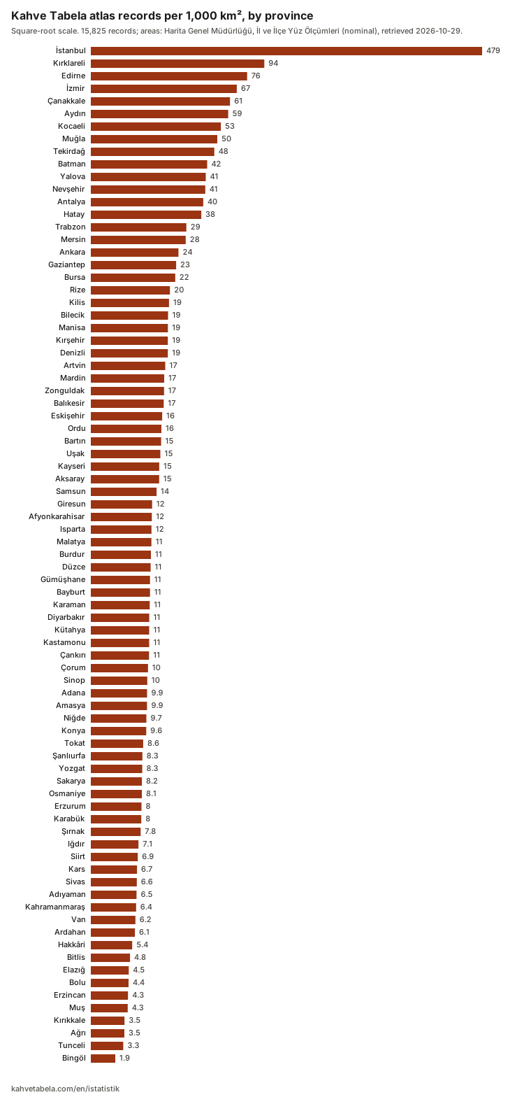
Records per 1,000 km², by province
- Türkiye
- 20.3
- İstanbul
- 478.9
- Bingöl
- 1.9
- districts with a record placed in them
- 915/973
The atlas holds 15,825 records today. Measured against Harita Genel Müdürlüğü's area figures, that is about 20 records per 1,000 km² across Türkiye. The spread is uneven: İstanbul has 479 records per 1,000 km², Bingöl fewer than 2.
- The five provinces with the highest density are, in order, İstanbul, Kırklareli, Edirne, İzmir and Çanakkale.
- The five with the lowest are Muş, Kırıkkale, Ağrı, Tunceli and Bingöl, with Bingöl last.
- 915 of Türkiye's 973 districts have at least one record with that district in the atlas; 58 have none. The 135 records with no district are not in this count, so a district the list shows as empty can still hold one.
- İstanbul478.9
- Kırklareli94.1
- Edirne76.4
- İzmir66.7
- Çanakkale60.6
- Aydın59.0
- Kocaeli52.9
- Muğla50.0
- Tekirdağ47.7
- Batman42.3
- Yalova41.3
- Nevşehir41.0
- Antalya39.5
- Hatay38.2
- Trabzon28.5
- Mersin28.2
- Ankara24.0
- Gaziantep22.8
- Bursa22.3
- Rize19.6
- Kilis19.1
- Bilecik18.7
- Manisa18.6
- Kırşehir18.5
- Denizli18.5
- Artvin17.3
- Mardin16.8
- Zonguldak16.8
- Balıkesir16.6
- Eskişehir15.9
- Ordu15.6
- Bartın15.5
- Uşak15.1
- Kayseri14.6
- Aksaray14.6
- Samsun13.5
- Giresun11.8
- Afyonkarahisar11.6
- Isparta11.5
- Malatya11.5
- Burdur11.3
- Düzce11.2
- Gümüşhane11.0
- Bayburt10.9
- Karaman10.9
- Diyarbakır10.7
- Kütahya10.7
- Kastamonu10.6
- Çankırı10.6
- Çorum10.2
- Sinop10.0
- Adana9.9
- Amasya9.9
- Niğde9.7
- Konya9.6
- Tokat8.6
- Şanlıurfa8.3
- Yozgat8.3
- Sakarya8.2
- Osmaniye8.1
- Erzurum8.0
- Karabük8.0
- Şırnak7.8
- Iğdır7.1
- Siirt6.9
- Kars6.7
- Sivas6.6
- Adıyaman6.5
- Kahramanmaraş6.4
- Van6.2
- Ardahan6.1
- Hakkâri5.4
- Bitlis4.8
- Elazığ4.5
- Bolu4.4
- Erzincan4.3
- Muş4.3
- Kırıkkale3.5
- Ağrı3.5
- Tunceli3.3
- Bingöl1.9
Bars use a square-root scale. Areas: Harita Genel Müdürlüğü, İl ve İlçe Yüz Ölçümleri, retrieved 2026-10-29; HGM states the figures are nominal and not official. 135 records have no district and count only toward their province.
Province table (CSV)All 973 districts (CSV)Chart (SVG)
Districts with no record placed in them (58)
A district with no record is not a district without historic places. The atlas compiles places recorded in open sources such as OpenStreetMap and Wikidata; an empty district means those sources do not record anything there yet. Read the list below as a worklist of where those sources fall short.
- Adıyaman
- Samsat, Tut
- Afyonkarahisar
- Başmakçı, Çobanlar, Evciler, Kızılören
- Aksaray
- Sarıyahşi
- Balıkesir
- Kepsut
- Bingöl
- Yedisu
- Bolu
- Dörtdivan
- Bursa
- Büyükorhan, Harmancık
- Çankırı
- Kızılırmak, Yapraklı
- Çorum
- Dodurga, Oğuzlar, Uğurludağ
- Denizli
- Bekilli, Beyağaç
- Diyarbakır
- Hani
- Düzce
- Gölyaka, Yığılca
- Elazığ
- Arıcak, Maden
- Erzurum
- Karaçoban
- Eskişehir
- Mihalgazi
- Giresun
- Doğankent
- Karabük
- Eflani
- Kastamonu
- Hanönü, İhsangazi
- Kırıkkale
- Bahşili, Çelebi
- Kocaeli
- Çayırova
- Kütahya
- Pazarlar, Şaphane
- Malatya
- Doğanyol
- Muş
- Hasköy
- Ordu
- Çamaş, İkizce, Kabataş
- Rize
- İyidere, Kalkandere
- Sakarya
- Akyazı, Erenler, Hendek, Karapürçek, Kaynarca, Söğütlü
- Sinop
- Dikmen, Saraydüzü
- Tokat
- Yeşilyurt
- Trabzon
- Dernekpazarı, Köprübaşı, Tonya, Yomra
- Tunceli
- Hozat
- Yozgat
- Çekerek, Kadışehri
Use this data
You may reuse these figures in stories, research, or teaching material. A citation is all we ask:
Kahve Tabela atlas · cultural heritage statistics, kahvetabela.com/en/istatistik · DOI: 10.5281/zenodo.23773096
Method: figures are recomputed from the atlas corpus on every deploy; each record's source (OpenStreetMap, Wikidata and community verification) is shown on its own page. Scope: the tables count the public sources compiled into the atlas; they are not the full official inventory, only the records that made it into the atlas.
Raw data (CSV, SHA-256 verified) and licensing: Open data page